FREE SHIPPING Over $30 -> Up to 50% Off!
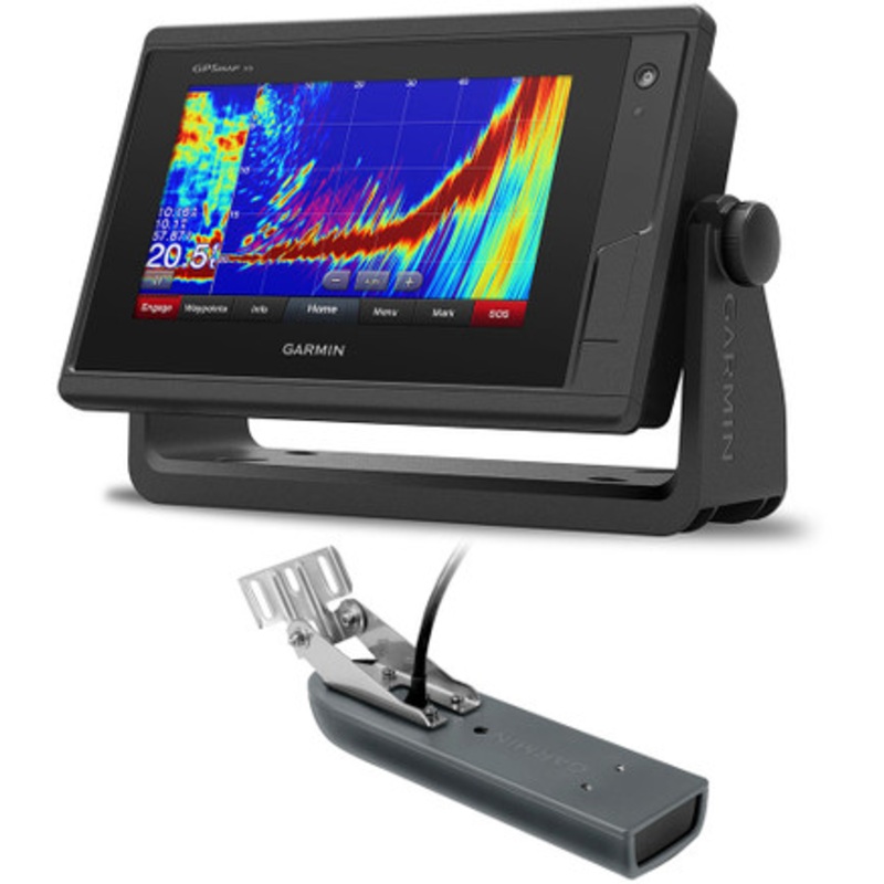
GPSMAP 742xs Touchscreen Chartplotter/Sonar Combo w/ CV23M-TM Transducer7-inch Touchscreen Chartplotter/Sonar Combo7-inch high-resolution intuitive touchscreen controlsNMEA 2000and NMEA 0183 support for network connectivity, including autopilots, digital s
GPSMAP 742xs Touchscreen Chartplotter/Sonar Combo w/ CV23M-TM Transducer
7-inch Touchscreen Chartplotter/Sonar Combo
Experience an advanced navigation solution with this compact 7-inch GPSMAP 742xs touchscreen combo. Includes wireless connectivity features for mobile apps, NMEA 2000 support and Garmin Marine Network capabilities for radar and Panoptix all-seeing sonar, including Panoptix FrontV collision avoidance sonar. It also has built-in Garmin CHIRP and CHIRP ClearV sonar (transducer sold separately).
Garmin Marine Network and NMEA 2000 Support
Full-network compatibility allows you to add more capabilities to your boat. Garmin Marine Network support allows sharing of sonar, including Panoptix sonar, maps, user data, Garmin radar, and IP cameras among multiple units. Plus, theres NMEA 2000 and NMEA 0183 support for connectivity including autopilots, digital switching, weather, FUSION-Link, VHF, AIS and other sensors.
Built-in Wi-Fi and ANT Connectivity
Enjoy built-in Wi-Fi and ANT wireless connectivity directly to quatixmarine watch,Garmin Nautix in-view display,gWind Wireless 2transducer,GNX Windmarine instrument and wireless remote controls. You can even stream and control aVIRB action camerafrom the chartplotter.
The Ultimate Connected Boating App
Built in Wi-Fi gives you access to the free all-in-oneActiveCaptain app, so you can manage your marine experience from nearly anywhere. It creates a simple yet powerful connection between your compatible mobile device and your Garmin chartplotter, charts, maps and the boating community. Wherever you are, youll have unlimited access to your cartography, the ability to purchase new maps and charts and access to the Garmin Quickdraw Contours Community. Stay connected with smart notifications on your chartplotter screen. You can also plan a trip or prefish a lake, and ActiveCaptain will automatically sync with your chartplotter. Even get notifications for software updates, and decide when to download them on your device.
Built-in Sonar Capabilities
Right out of the box, you have access to some amazing sonar capabilities; all you add are transducers. Comes with built-in Garmin 1 kW CHIRP sonar and CHIRP ClearV scanning sonar. It even supports Panoptix all-seeing sonar, premium Garmin sonar modules and a wide range of transducers (sold separately).
Networked combos can share their internal sonar with any other device on the network. You can also choose what information is overlaid on the sonar screen, for example, radar, time of day or GPS speed.
Heading and Position Refreshed 10 Times per Second
Fast, responsive built-in 10 Hz GPS and GLONASS receiver refreshes your position and heading 10 times each second to make your movement on the screen more fluid. It makes dropping up to 5,000 accurate waypoints and finding your way back to them quick and easy.
Preloaded with Exceptional Garmin Cartography
You get bothLakeV HDinland waters mapping andBlueChart g2coastal charts covering the coastal U.S. (East Coast, West Coast, Gulf of Mexico, U.S. and the Canadian side of the Great Lakes).
LakeV HD provides highly detailed freshwater maps that include 17,000+ U.S. lakes, rivers and reservoirs. Included in those are more than 13,000 HD lakes with 1-foot contours shoreline to shoreline. Upgrade toLakeV HD Ultrawith Max Def Lakes.
BlueChart g2 provides basic coastal charts, tidal and current stations, depth contours, IALA nav symbols and fishing charts.
Upgrade to Our Best Maps on the Water
Includes expandable memory for accessory map purchases, such asBlueChart g2 Vision HD, which adds Garmin patented Auto Guidance and other great features.
Quickdraw Contours to Create Your Own HD Maps
Instantly create personalized HD fishing maps on-screen with 1-foot contours. Tailor them to fit your needs. These are your maps you own them. Keep the data to yourself, or share it with the Quickdraw Community on Garmin Connect.
Built-in SailAssist Features
To help you gain a wind-maximizing competitive edge, your chartplotter features a pre-race guidance page that shows your virtual starting line along with data fields showing laylines, time to burn before the start and a race timer that can be synchronized across all your networked Garmin GPS products. In addition, other supported sailing features include an enhanced wind rose, heading and course-over-ground lines, set and drift, true and apparent wind data and more.
GPX Waypoints Transfer
If you have waypoints, tracks or frequently used routes stored on another manufacturers GPS product or on a Garmin handheld device its easy to transfer those items to your new Garmin chartplotter via industry-standard GPX software formatting.
Features:
In The Box
Connections
 sale
sale
 sale
sale
 sale
sale
Copyright © 2025 .All Rights Reserved.Powered by www.boatmaintenances.com
Reviews
There are no reviews yet.