FREE SHIPPING Over $30 -> Up to 50% Off!
ECHOMAP Plus 64cv BlueChart G3 with GT23M-TM TransducerThe Combo with ConnectionsBright, sunlight-readable 6 comboIncludes GT23 transducer for Garmin CHIRP traditional sonar plus CHIRP ClearV scanning sonar with transom and trolling motor mountsPreloaded B
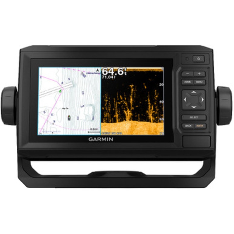
ECHOMAP Plus 64cv BlueChart G3 with GT23M-TM Transducer
The Combo with Connections
Bright, sunlight-readable 6 combo includes one transducer that features both Garmin CHIRP traditional sonar and CHIRP ClearV scanning sonar. It comes preloaded with BlueChart g3 charts with integrated Navionics data, covering the coastal U.S. Plus,Quickdraw Contoursmapping software to to instantly create personalized fishing maps on-screen with 1 contours as you fish. It also has built-in Wi-Fito pair with the freeActiveCaptainapp for access to OneChart, which allows you to purchase and download new charts. ActiveCaptain also gives you access to smart notifications1, the ActiveCaptain community for marina and other points of interest details, Quickdraw Community data and more. You can also share waypoints and routes with other ECHOMAP or STRIKER units. Features quick-release bail mount to make it easy to remove and take with you. Transom and trolling motor mounts included.
The Garmin CHIRP Difference
The built-in sonar capabilities of ECHOMAP Plus 64cv include Garmin’s CHIRP traditional sonar, one of the most sophisticated sonar technologies available for the fishing and boating public. CHIRP traditional sonar provides amazingly clear target separation and definition, because it puts even more energy onto the target than traditional sonar. It also provides traditional sonar support for Minn Kota and MotorGuide trolling motors with integrated transducers.
Clear Scanning Sonar Images
Garmin CHIRP ClearV scanning sonar gives you a nearly photographic, wide image of what passes below your boat. You clearly see structure, submerged objects and fish. Garmin CHIRP traditional sonar and ClearV scanning sonar are combined into 1 transducer.
Preloaded BlueChart g3 Charts
This ECHOMAP Plus combo features preloaded BlueChart g3 charts with integrated Navionics data, covering the coastal U.S. (east coast, west coast, Gulf of Mexico, U.S. and the Canadian side of the Great Lakes). Data is derived from official charts and private sources to provide navigational aids, spot soundings, depth contour, tides and currents and more.
Quickdraw Contours to Create Your Own Maps
Instantly create personalized fishing maps on-screen with 1 contours. Tailor them to fit your needs. These are your maps you own them. Keep the data to yourself, or share it with the Quickdraw Community on Garmin Connect.
Get Connected with ActiveCaptain App
Garmin’s free all-in-one ActiveCaptain mobile app allows you to manage your marine experience from nearly anywhere. It creates a simple yet powerful connection between your compatible mobile device and your chartplotter, charts, maps and the community. Use the combos built-in Wi-Fi to pair with the free ActiveCaptain app for access to OneChart, which allows you to update or purchase and download new charts. ActiveCaptain also gives you access to smart notifications1, the ActiveCaptain community for marina and other points of interest details, Quickdraw Community data and more.
Garmin SailAssist Features
SailAssist features include laylines, enhanced wind rose, heading and course-over-ground lines. See true and apparent wind angle and speed as well as set and drift and a glance. To help you gain a wind-maximizing competitive edge, a pre-race guidance page that shows your virtual starting line along with data fields showing laylines, time to burn before the start and a race timer.
Upgrade to Garmin’s Best Maps on the Water
Step up to Garmin’s premier BlueChart g3 Vision coastal charts, LakeV g3 inland maps or LakeV g3 Ultra inland maps with Garmin Elite survey lakes all featuring integrated Navionics data, Auto Guidance2 technology, Depth Range Shading and other great features. A single microSD card slot provides expandable memory for accessory map purchases. Or purchase maps with OneChart through the ActiveCaptain app, and automatically sync with your compatible chartplotter, eliminating the need for an SDcard.
NMEA 2000 Network Support
ECHOMAP Plus 64cv provides NMEA 2000 support for engine data, sensors, FUSION-LINK audio system, autopilots and more.
Take Your ECHOMAP Plus with You
When youre off the water, its easy to keep your ECHOMAP Plus combo safe and secure. You dont have to mess with plugging and unplugging wires from the unit because the cords plug directly into the mount. This allows you to quickly install and remove your ECHOMAP Plus from power and the mount.
Connections:
In the box:
When paired with a compatible mobile device.
Auto Guidance is for planning purposes only and does not replace safe navigation operations.
Wi-Fi is a registered trademark of the Wi-Fi Alliance.
Copyright © 2025 .All Rights Reserved.Powered by www.boatmaintenances.com
Reviews
There are no reviews yet.