FREE SHIPPING Over $30 -> Up to 50% Off!
C-Map NT+ Electronic Marine Charts are the standard that ushered in contemporary digital charting. One of the most reliable chart options for boaters worldwide, NT+ charts continue to deliver exceptional quality and value to navigators worldwide. C-Map's c
C-Map NT+ Electronic Marine Charts are the standard that ushered in contemporary digital charting. One of the most reliable chart options for boaters worldwide, NT+ charts continue to deliver exceptional quality and value to navigators worldwide. C-Map’s classic line of electronic charts offers the same reliable navigation detail easy-to-use features you expect in all C-MAP by Jeppesen products.
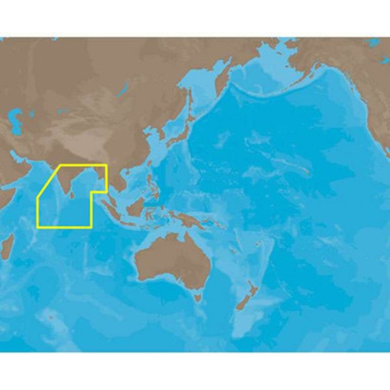
C-MAP NT+ IN-C202 – Maldives-Gulf of Martaban – Furuno FP-Card Coverage:
Coverage of Maldives to Gulf of Martaban in Burma.
It covers Chagos Archipelago, Diego Garcia, and Maldives.
Also covered are Androth Island, Kalpeni, Kadmat, coastal areas along Trivandrum, Quilon, Kochi, Mangalore, Vengurla, Kataka, Vishakhapatnam, kakinada, Vadarevu, Madras, Pondicherry, Tircuhchiappalli, Jaffna, Tiruneveli, Nagercoil, Qulon and Adaman Island in India.
Coastal areas along Trincomalee, Colombo, Galle in Sri Lanka, Chittagong in bangladesh are also covered. It also covers Sittwe, Rangoon and Ranong in Burma.
More Features and Specifications
 sale
sale
 sale
sale
 sale
sale
Copyright © 2025 .All Rights Reserved.Powered by www.boatmaintenances.com
Reviews
There are no reviews yet.