FREE SHIPPING Over $30 -> Up to 50% Off!
C-Map NT+ Electronic Marine Charts are the standard that ushered in contemporary digital charting. One of the most reliable chart options for boaters worldwide, NT+ charts continue to deliver exceptional quality and value to navigators worldwide. C-Map's c
C-Map NT+ Electronic Marine Charts are the standard that ushered in contemporary digital charting. One of the most reliable chart options for boaters worldwide, NT+ charts continue to deliver exceptional quality and value to navigators worldwide. C-Map’s classic line of electronic charts offers the same reliable navigation detail easy-to-use features you expect in all C-MAP by Jeppesen products.
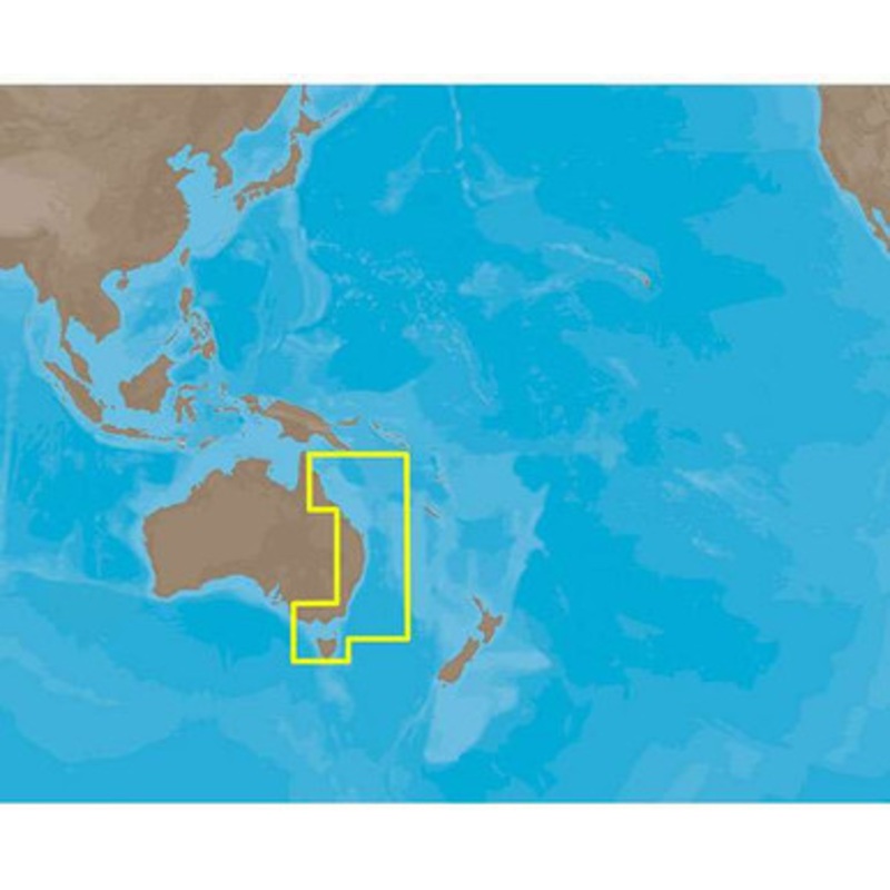
C-MAP NT+ AU-C219 – Port MacDonnell-Prince Charles – C-Card Coverage:
Coverage to Port Macdonell to Prin.Charlotte Bay cover’s Port Land, Melbourne, Hastings, Phillip Island, Port Albert, Twofold Bay, Batemans Bay, Jervis Bay, and Shell Harbour.
Coverage also includes Port Kembla, Flagstaff Point, Port Hacking, Botany Bay, Sydney Harbour, Pittwater, Entrance to Swansea, Newcastle Harbour, Port Stephens, and Broughton Island.
Also covered are The Entrance to Forster, Entrance to Laurieton, Entrance to Port Macquarie, Coffs Harbour, Entrance to Clearance River, Entrance to Tween River, Gold Coast, Moreton Bay, Brisbane Harbour, Fraser Island, Bunderberg, Gladestone, Mackay, Airlie Beach, Townsville, Great Barrier Reef as well as Flinders reef, Lord Howe Island, King Island, Flinders Island and Tasmania.
More Features and Specifications
 sale
sale
 sale
sale
 sale
sale
Copyright © 2025 .All Rights Reserved.Powered by www.boatmaintenances.com
Reviews
There are no reviews yet.