FREE SHIPPING Over $30 -> Up to 50% Off!
Max-N Wide Cartography f/Lowrance, Simrad Yachting & B&G Chartplotters and Multifunction DisplaysMAX-N Wide provides additional C-MAP features such as harbor, detailed marina charts and coverage of inland rivers and lakes. When you choose C-MAP you get the
Max-N Wide Cartography f/Lowrance, Simrad Yachting & B&G Chartplotters and Multifunction Displays
MAX-N Wide provides additional C-MAP features such as harbor, detailed marina charts and coverage of inland rivers and lakes. When you choose C-MAP you get the best charts, using the most reliable sources around the globe, from a company committed to safe navigation.
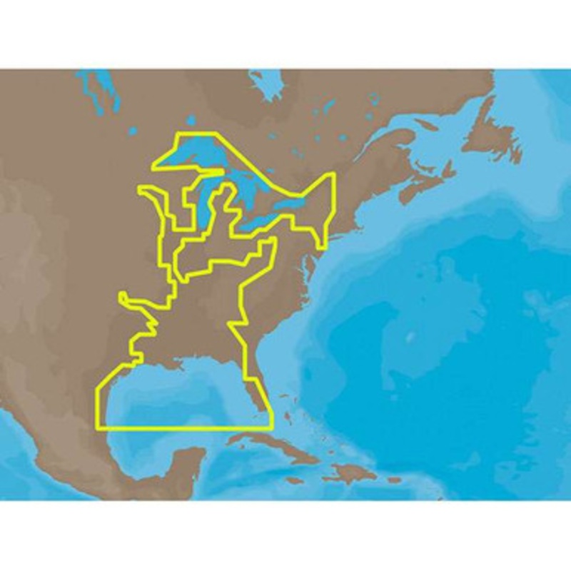
C-MAP MAX-N NA-N023 – US Gulf of Mexico, Great Lakes & Rivers Coverage:
Coverage of the Gulf states, starting from Boca Raton, FL, down to Key West, FL, then back up and around the Gulf to Brownsville, TX.
Also includes coverage of all the Great Lakes: Erie, Superior, Ontario, Huron and Michigan.
Coverage of the Great Lakes also includes Fox River and Lake Winnebago, Lake St. Clair and the Trent-Severn Waterway. River coverage includes the Mississippi River, Ohio River, Illinois River, Arkansas River, Red River, Ouachita River, Tennessee River, Cumberland River, Tenn-Tom Waterway and the Black Warrior River.
Other smaller rivers are also included: Green River, KY, Kanawha River, WV, Allegheny and Monongahela Rivers, PA and Kankakee River, IL.
Additional coverage of the Hudson River, including Lake Champlain, down to New York City, the Erie Barge Canal and partial coverage of the St. Lawrence River up to Montreal.
More Features and Specifications
 sale
sale
 sale
sale
 sale
sale
Copyright © 2025 .All Rights Reserved.Powered by www.boatmaintenances.com
Reviews
There are no reviews yet.