FREE SHIPPING Over $30 -> Up to 50% Off!
CMAP MAX Electronic Charts:Bring your electronic charts to life with MAX, the ultimate navigator, and make cruising, sailing and fishing easier, safer and more fun. You'll benefit from the most accurate chart detail, versatile features and a wealth of impo
CMAP MAX Electronic Charts:
Bring your electronic charts to life with MAX, the ultimate navigator, and make cruising, sailing and fishing easier, safer and more fun. You’ll benefit from the most accurate chart detail, versatile features and a wealth of important data.
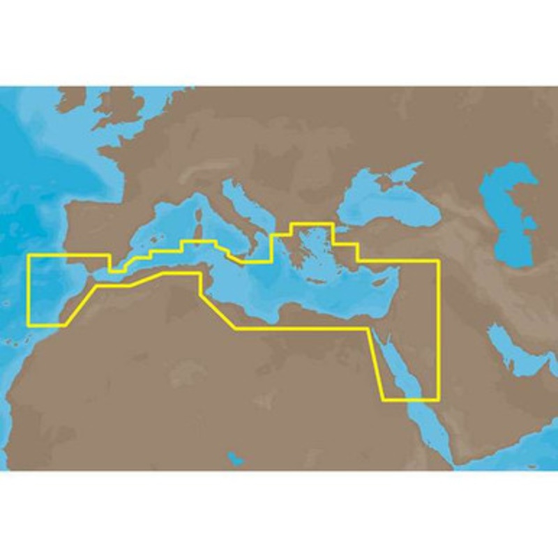
C-MAP MAX EM-M112 – South Mediterranean Sea and Aegean Sea C-Card Coverage:
South Mediterranean Sea and Aegean Sea: Greece to entrance of Sea of Marmara (partial coverage).
SW Turkey, Syria, Lebanon, Israel, Egypt (including Suez Canal and Gulf of Aqaba) Libya and Saudi Arabia.
Red Sea coverage ends south of Jeddah, Saudi Arabia.
Coverage of the Mediterranean coast of Africa including Egypt, Libya, Tunisia, Algeria to Agadir, Morocco.
Also covers the SW coast of Sicily, the southern tip of Sardinia and parts of Southern Spain from Adra to Sines, Portugal.
More Features and Specifications
 sale
sale
Copyright © 2025 .All Rights Reserved.Powered by www.boatmaintenances.com
Reviews
There are no reviews yet.