FREE SHIPPING Over $30 -> Up to 50% Off!
C-MAP 4D Electronic Marine Charts are the next evolution in navigation solutions. C-MAP 4D adapts to your boating needs because it's the only digital chart that offers advanced features and lets you add data and services as they become available.C-MAP 4D c
C-MAP 4D Electronic Marine Charts are the next evolution in navigation solutions. C-MAP 4D adapts to your boating needs because it’s the only digital chart that offers advanced features and lets you add data and services as they become available.
C-MAP 4D cartography is compatible with the Furuno 1670F / 1870F, and Standard CPN 7000i, and CPN1010i units.
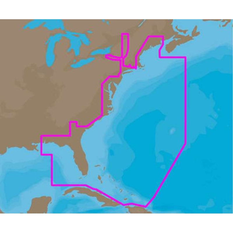
C-MAP 4D NA-D022 – USA East Coast & Bahamas – Full Content Coverage:
Coverage of the United States Atlantic coast from Passamaquoddy Bay, ME down to Key West, FL, with extended coverage into the Gulf of Mexico over to Perdido Bay, FL.
Includes coverage of Bermuda and all of the Bahamas.
Also includes coverage of the Hudson River, Lake Champlain, Erie Barge Canal, Savannah River, St John’s River and Okeechobee Waterway.
Caribbean coverage includes charts from Explorer Chartbooks and Wavey Line Publishing.
More Features and Specifications
 sale
sale
 sale
sale
 sale
sale
 sale
sale
Copyright © 2025 .All Rights Reserved.Powered by www.boatmaintenances.com
Reviews
There are no reviews yet.