FREE SHIPPING Over $30 -> Up to 50% Off!
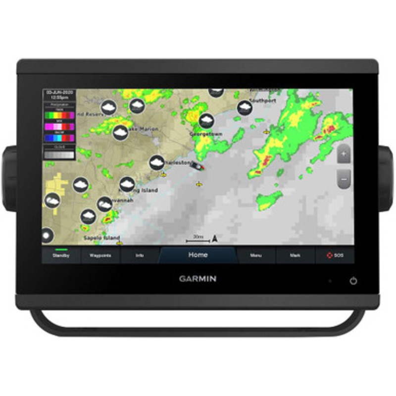
GPSMAP 943 Chartplotter - Preloaded US+Canada+Bahamas BlueChart g3 - LakeV g3Get a sharper view from your connected helm with the GPSMAP 943 chartplotter. Its higher-resolution 9 in-plane switching display has 50% more pixels than previous-generation touch
GPSMAP 943 Chartplotter – Preloaded US+Canada+Bahamas BlueChart g3 – LakeV g3
Get a sharper view from your connected helm with the GPSMAP 943 chartplotter. Its higher-resolution 9 in-plane switching display has 50% more pixels than previous-generation touchscreens. The ultrasleek design and nearly double the processing power of previous-generation GPSMAP devices offer seamless integration into your Garmin marine system. Preloaded BlueChart g3 coastal charts and LakeV g3 inland maps give you the best of Garmin and Navionics data with built-in Auto Guidance1 technology for confidence in helping you get where you need to go. Easily build your marine system from compatible sonar and autopilots to compatible radar, cameras and multimedia using HTML 5.0, NMEA 2000 and NMEA 0183 network connectivity, J1939 for engines and the Garmin Marine Network. Add Panoptix FrontV forward-looking sonar2 (sold separately) for help in avoiding underwater obstructions ahead. Or pair your plotter with your other compatible Garmin devices, such as quatix marine smartwatches, wind transducers, wireless remote controls and more.
Features:
1 Auto Guidance is for planning purposes only and does not replace safe navigation operations
2 The ability to effectively avoid forward collisions with FrontV sonar decreases as speed rises above 8 knots
3 Requires compatible wind transducer (sold separately)
4 Requires app on your compatible smartphone; see Garmin.com/ble
Wi-Fi is a registered trademark of the Wi-Fi Alliance.
 sale
sale
 sale
sale
 sale
sale
 sale
sale
Copyright © 2025 .All Rights Reserved.Powered by www.boatmaintenances.com
Reviews
There are no reviews yet.