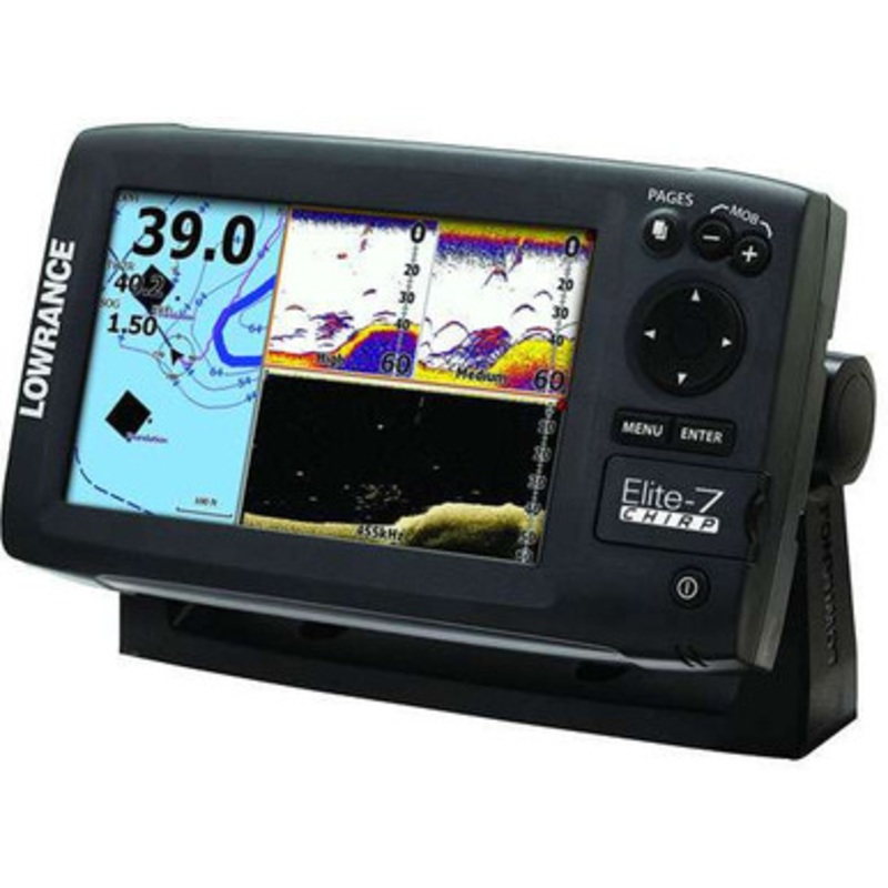
Lowrance Elite-7 CHIRP Gold Fishfinders/Chartplotters combine CHIRP Sonar with DownScan Imaging, built-in GPS antenna and Navionics Gold high-definition mapping. CHIRP Sonar technology provides greater sensitivity, improved target resolution and superior noise rejection for clearer, easy-to-see bait fish and game fish targets. The pre-packaged Navionics Gold chartcard features U.S./Canada/Alaska and Bahamas coastal, Great Lakes and major Canadian lakes detail.
CHIRP Sonar Advantages
- Easier to identify and distinguish bait and game fish targets
- Better target identification at greater depths
- Mark fish clearly at faster boat speeds
Exclusive Lowrance Elite-7 CHIRP Gold advantages
- Multiple CHIRP frequencies from a single transducer
- CHIRP sonar performance with a greater number of affordable transducers, including the Lowrance HDI Skimmer
- View multiple CHIRP sonar settings on one display
More Features and Specifications
Exclusive Lowrance Elite-7 CHIRP Gold features
- DownScan Imaging provides picture-like images of fish-holding structure beneath a boat.
- Selectable single-frequency sonar operation with award-winning Broadband Sounder performance.
- Highly accurate, built-in GPS antenna plus a detailed U.S. map featuring more than 3,000 lakes and rivers and coastal contours to 1,000 feet.
- Navionics Gold chartcard featuring U.S./Canada/Alaska and Bahamas coastal, Great Lakes and major Canadian lakes detail.
- Optional chart upgrades include Lake Insight and Nautic Insight PRO and HD, Navionics HotMaps Premium, Fishing Hotspots PRO and Jeppessen C-Map Max-N.
- Create your own map from real sonar data that you record with Insight Genesis
- Brilliant Elite color display for enhanced widescreen visibility and viewing detail in all conditions
- DownScan Overlay technology overlays DownScan Imaging onto CHIRP Sonar
- Advanced Signal Processing (ASP) reduces the need to manually adjust settings to see fish, structure and bottom detail more clearly
- TrackBack to review recorded sonar history including structure, transitions or fish targets, then pinpoint locations with a waypoint.
- New page selector menu with quick access to all features using one-thumb operation
- Multi-Window Display lets you quickly choose from pre-set page layouts – including a three-panel view with chart, CHIRP sonar ranges and DownScan Imaging.
- Supported by Lowrance Advantage Service program
Lowrance Elite-7 CHIRP Gold Specifications
| Overview |
| Display |
7 in./178 mm (16:9) Full VGA SolarMax Plus |
| Resolution |
16-bit color TFT 800 x 480 |
| Backlighting |
LED |
| Power Output: RMS (PTP) |
Max 250W RMS, 30,000W Peak to Peak (analog equivalent) |
| Operating Frequency |
455/800 kHz (DownScan Imaging), Low, Med, High (CHIRP), 50 kHz/83kHz/200kHz (Narrow Band) |
| Languages |
31 |
| Media Port |
One (1) microSD slot |
| Operating Voltage |
12 vDC (10-17 vDC min-max) |
| Warranty |
One year |
| Display |
| Display Resolution |
800 x 480 |
| Display Type |
16-bit color SolarMAX PLUS TFT |
| Display: Backlighting |
LED |
| Backlighting Levels |
Adjustable Screen And Keypad |
| Display Size |
7 inches / 178 mm |
| Sonar |
| Depth Alarm |
Yes |
| EchoSounder Frequencies |
83/200 kHz + 455/800 kHz |
| Shallow Alarm |
Yes |
| Temperature Readings |
Yes |
| Transducer Type |
Multiple selections Lowrance and Airmar |
| Max Depth per Type |
DownScan Imaging at 455 kHz:Max 300 ft / 91 m
CHIRP Sonar High Range/200 kHz:1,000 ft / 305 m
CHIRP Sonar Med Range/83 kHz:1000 ft / 305 m
CHIRP Sonar Low Range/50 kHz:3,000 ft/914 m
|
| Technical/Environmental |
| Waterproof Standard/rating |
IPx7 |
| Product Width |
9.26 in \ 235 mm |
| Product Depth |
3.0 in \ 76 mm |
| Product Height |
5.95 in \ 151 mm |
| Power |
| Power Supply (Supply Voltage) |
12 vDC (10-17 vDC min-max) |
| GPS Navigation |
| Navigation: Routes |
100 |
| Navigation: Waypoint Storage |
3000 |
| GPS Antenna Type |
Internal high-sensitivity WAAS + EGNOS + MSAS (optional external antenna) |
| Plot Trails |
Up to 100 trails – up to 10,000 points / trail |
| GPS Alarms |
Yes |
| Custom Mapping |
Lake Insight and Nautic Insight PRO and HD, Insight Genesis, Navionics Gold (included) and HotMaps Premium, Fishing Hotspots PRO and Jeppessen C-Map Max-N.
|
| Background Mapping |
World reference basemap or (U.S. models) over 3,000 enhanced lake maps with depth contour and shoreline detail, plus coastal depth contours/shoreline detail and spot depth soundings to 1,000 ft./305 m |
| Networking Connectors |
| NMEA Output |
NMEA 0183 and NMEA 2000 |
| Other |
| Languages |
31 |
| Output Power [kW] |
12 W (0.9 A @ 13 vDC) |
| Memory Card Capable |
Yes |
Reviews
There are no reviews yet.