FREE SHIPPING Over $30 -> Up to 50% Off!
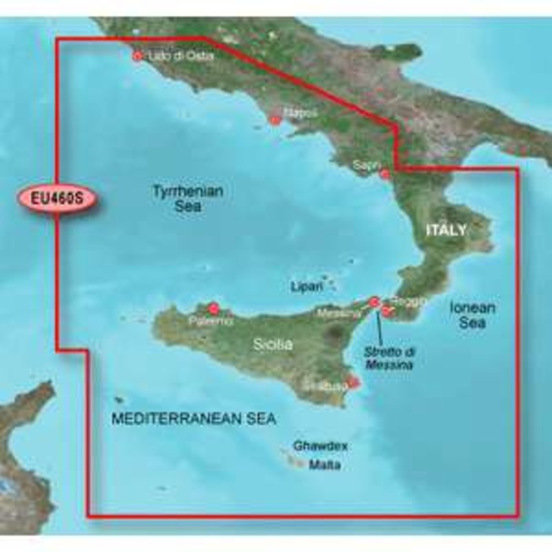
HXEU460S Covers:Detailed coverage of southwestern Italy from Lido di Ostia to Rossano. Also includes complete coverage of Napoli, Palermo and Siracusa as well as the islands of Sicilia and Malta. Garmin BlueChart g2 marine maps feature crisp labeling and a
HXEU460S Covers:
Detailed coverage of southwestern Italy from Lido di Ostia to Rossano. Also includes complete coverage of Napoli, Palermo and Siracusa as well as the islands of Sicilia and Malta.
Garmin BlueChart g2 marine maps feature crisp labeling and an overall smoother presentation on your chartplotter display. In addition to the basic charts, tidal stations, currents, depth contours, IALA symbols and included fishing charts, BlueChart g2 offers improved transitioning between zoom levels and more seamless continuity across chart boundaries.
Customize Your Screens
BlueChart g2 also adds Safety Shading which allows the user to enable contour shading for all depth contours shallower than the user-defined safe depth. The fishing charts are designed to emphasize bathymetric contours with less visual clutter on the display. There’s also a choice of standard 2-D direct overhead or 3-D “over-the-bow” map views for easier chart reading and orientation.
Features found on BlueChart g2:
BlueChart Compatibility
 sale
sale
 sale
sale
 sale
sale
Copyright © 2025 .All Rights Reserved.Powered by www.boatmaintenances.com
Reviews
There are no reviews yet.